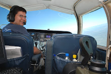
The Office

With three GPS systems on board I shouldn't ever get lost. The big color screen is my primary navigation system for aerial survey. It is a touch screen that controls a windows based laptop with Track-Air software loaded onto it. The little color display to the right is a Garmin 296 which is a handheld GPS that has terrain & airspace information to help me maintain situational awareness. The third GPS is a panel mounted IFR GPS that I can use while I'm in the clouds.
posted by Vince at 3:23 PM
![]()

0 Comments:
Post a Comment
<< Home